


Let’s say you have a favourite book. And then you happen to meet the author(s). And THEN you get to go on a tour documenting the places mentioned in the book. AND, on this tour, the author is your tour guide!
That’s what our day was like, this past Monday!
I’ve established many times by now, that the Historical Atlas of the East Reserve is one of my favourite books, as it documents each ghost-village, and includes many dynamic, easy-to-read maps.
And its authors, Ernest Braun and Glen Klassen, live here in Hanover (that’s what the East Reserve area is now called), so we simply chose a day, and off we went!
Glen joined us for the morning (I will write more about that in upcoming posts) and after lunch, Ernest drove Andrew and I out to see Schönsee, a village located just a few short miles from where I grew up. Except of course Schönsee ceased to exist in the 1920’s when the majority of its villagers moved to Paraguay… so I never knew of this village. Nor any of these villages.
I’m writing about our visit to Schönsee first, immediately, because it was a real highlight, and I’m afraid of forgetting.
As we zipped along gravel roads toward Schönsee, Ernie spoke of the project of working on the Atlas. “It’s a labour of love”, he said, accelerating to speeds that Andrew and I likely wouldn’t have been comfortable with, had either of us been behind the wheel.
“As I drive through Hanover, I see villages… they’re super-imposed on the landscape, three-dimensional… they’ve permanently become a part of my consciousness, a part of my thinking,” said Ernie. “Even though their footprint has morphed into something new.”
I’ve been reading the Historical Atlas of the East Reserve so much that by now, I see the villages too.
But really… I’ve always seen them. I’ve always imagined villages in the woods where I grew up. Maybe that’s why I’m so fascinated to learn that they’d actually existed, for however short amount of time.
“I was determined to map every village in the East Reserve,” Ernie continued. That’s how he discovered the remarkable remnants of Schönsee. “Here we are,” he said.
The first thing I saw was the cemetery, and I was eager to get out and wander, but there would be time for that later. First, we met Carol and Darcy, siblings who grew up here. This is their land, they were graciously hosting and guiding us, and they’d also contacted their neighbours and obtained permission to bring us onto adjoining property where the rest of Schönsee could be found.
Here’s the thing about Schönsee — the land that this village had been located on is not great for growing crops, it makes for much better pasture land. And thank goodness — because of this, it’s remained relatively untouched for the past century! With the exception of peacefully grazing cows, that is.
How can I express how remarkable this is? Consider this. All that really remains of all the other village sites are some gravestones… if you’re lucky. Often these too have crumbled and disappeared into the cultivated landscape. Yet here, so much remained!
We ventured into the pasture, noting the tall cottonwoods lining the “street”, typical of Mennonite villages.

We were immediately shown where the foundations of the original homes were. Carol said that she remembered playing on these foundations as a little girl. I totally get that. There’s something about a leftover foundation that makes you want to play balance-beam.
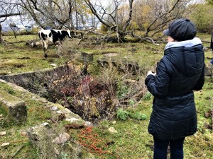
The cows were very curious about what we were up to… but, we weren’t there for the cows, they were just a bonus. They’ve certainly proven to be excellent guardians of these foundations.

I think we all felt like little kids.


Possibly the most youthful of us all was Ernie, climbing trees and descending into creeks.

I have more to tell you! But this is really too long already. More next week!