The weird angle of Steinbach’s main street probably first bothered me when I was learning to drive. “Ugh,” I’d exclaim in exasperation, “This street doesn’t make ANY sense. WHY is it like this?”
I suppose it was my dad who would have been teaching me to drive, who replied, “Well, the early pioneers chose the way main street would go, so I guess you can blame them.”
“Well I DO blame them. They should’ve thought of ME, today, right now, when they made this street.”
At this, he was quiet, as my statement was clearly ridiculous.
“AND ANOTHER THING!” I continued, as I navigated along Elmdale Street, “What’s with this weird double-street? It doesn’t even make sense!”
“It’s because of the creek,” he explained.
“What creek?” I paused. “Wait… do you mean this ditch? HOW is this even a creek?”
Those days of me learning to drive were rather… fraught. And the strange streets and angles of downtown Steinbach were not really to blame. I’m just mentioning this because it’s really my first memory of noticing its street-related oddities. (I’m not from Steinbach, you see. So, this was my first time really exploring it.)
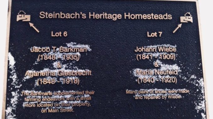
Several years later, these plaques went up along Historic Stony Brook, which follows Elmdale Street from Brandt Street (which is what Highway 12 is called as it winds its way through town).
Elmdale is indeed a strange street, paralleling Main Street one block over, laid out inconsistently on both sides of the ditch that was once the Stony Brook (before its diversion).
Since my angsty teenage driving lessons, I’ve learned that the first Mennonites to settle here were pretty much choosing the leftover portion of the East Reserve as their boat had come a little later than those who settled in Gruenfeld, Tannenau, and whatnot. But, there was a little brook, and so they set up their street along the brook, with their housebarns all in a row between the street and the creek. Thanks to these plaques (and the visual example of the Mennonite Heritage Village), it’s a little easier to get an idea of what this layout was like.

It’a also nifty to compare these names with Grandma’s Window, figure out my own genealogy, match up the names and dates, and know that my great-great-great-grandparents had lived precisely, exactly, here.

And the realization washes over me, that judging by the placement of the plaques, Barkman Street was very likely named for the exact Barkman family that my grandpa’s mother had hailed from.
(You know, just like thousands of other local Mennos. Heh.)

Here are a few of the other plaques. Sometimes I take pictures of them. Usually in winter, apparently.

See any names you recognize from your Grandma’s Window account?


