


EAST RESERVE
The first time I saw Rosengard, it was from a school bus window.

My brothers and I had the misfortune of living near our bus drivers… which meant we had to endure the full length of the headache-inducing bus ride every day after school.
For over a decade, every weekday afternoon from about 3:45 to 4:45, we bounced along dusty gravel roads, tumbling about inside that orange contraption along with a fairly random assortment of schoolmates.
The first time the school bus made an awkward turn up a sudden incline onto a road populated with houses and old barns on both sides, I was intrigued.
I’d never seen anything like it.


Remnants of a Mennonite street village?
As far as I can figure, it’s the only one like it here on the East Reserve.
—
Shortly after I learned of Neubergthal’s existence, I began to wonder if the East Reserve could have its own authentic Mennonite street village too. I wondered… could Rosengard become that place?
I now am fairly sure it could not.
Mostly because it’s its own thing: a village situated upon an ancient gravel ridge.
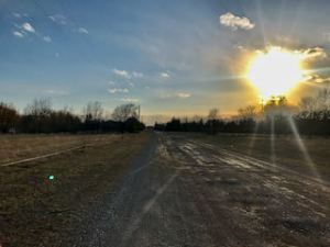
First, there is Ridge Road, a trail favoured by folks long before Mennonites arrived.
As the inland ocean of Lake Agassiz retreated at the end of the last ice age, this gravel ridge was left behind.
When the land would flood each spring, this ridge would rise above the waters, creating a trail that would be easily traversed in all weather and seasons. This trail was likely well-used by Indigenous people.
When Mennonites arrived, they naturally followed suit, and called this trail Ridge Road (though, I suppose, in Plautdietsch) as it snakes its way north from Grunthal to Steinbach.
I love the idea of trails that follow geological patterns, often as-the-crow-flies, creating direct paths between points.
When you think of it, the grid system is comparatively not very intuitive at all.
The government divided all this land into square sections and assigned ’em all to European settlers. Road allowances further divided the land according to the grid, but the road conditions were terrible, so tried-and-true trails such as Ridge Road were used well into the 20th century. Those living on land with popular trails passing through had a real problem with this and petitioned the government to build better roads so the trails would fall into disuse.
Today, Road 303 is still called Ridge Road… however, it does not follow the actual ridge. Instead it follows a straight line east-west. However, it does intersect with the real, true, original Ridge Road trail on the east side of Rosengard, precisely where the church stands today.
For the most part, the diagonal trail itself eventually became a series of lengthy flood-proof driveways leading to private farms. But it also became Rosengard Road, running one tilted mile through Rosengard.
Travel patterns may shift due to land ownership, but geology persists. You can still see remnants of the original Ridge Road trail, if you peer at it on google satellite view.
Related posts: