


EAST RESERVE
I need to write about things before I forget them. I think I should be calling myself “the forgetful, confused wannabe amateur Mennonite historian” or something. Anyway. A few weeks ago, I asked someone I barely knew if she would lead me into the woods behind her place.

I say that I barely knew her, but when you’re in a small community for a few decades, you know enough. I knew she was my kind of person. That is to say, she’s the kind of person who would happily show me the portion of the old Barkfield Trail that’s on her property, if I’d ask nicely.
She also was happy to let me stop and look at old stuff like this seeder.

It was magic hour. I stopped to take a picture and for a fleeting moment saw something looming in the periphery.

“I thought for a second I saw a house,” I remarked, shaking my head slightly in an effort to dislodge any latent cobwebs.
She told me there was probably a house here at one time. This had been a yard site. She began to show me the signs.
First this:
She suspects it was a well. Naturally, I climbed right into that thicket and kinda fell down a few feet, pushed aside some branches and saw that there is indeed a stone wall down here:

Whether it’s a well or a cellar, we do not know. But… it’s something.
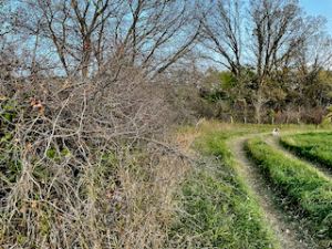
And then, she led me to the old Barkfield Trail.

The portion of the trail that’s on her land is not very far, but it’s certainly there and absolutely no one has maintained it for about 100 years. Yet the trail remains. How and why? Was the earth so compacted by foot traffic that no trees or shrubs would grow upon the trail itself?
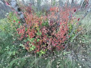
Emerging from the trail, she showed me a thicket that tends to only grow on farmyards. I forget what it’s called. (Apologies to anyone who stumbled across this blog hoping for help in actual research.)

Her dad had lived here in this very area and had told her that this portion of the field, here, beyond the oaks, on the rise, had been a community garden for the village of Gruenthal, long ago. The plots had been separated by… little hedges? Am I making this up now? I worry I’m getting the details a little scrambled. But it seems to me this spot was used because it was on a fertile hill (not too many of those in the gravelly area of Grunthal) along the Sarto Drain and the very popular Barkfield Trail. There was a natural crossing of the “Drain” in the woods behind us, but we did not go there because that’s someone else’s land.
This trail is located just outside of Grunthal, to the south.
So, I consult the Historical Atlas of the East Reserve (as I do), and I see this trail connected Bergfeld and Grunthal. The larger story here is that this was a major trail because it went on to connect to Schoensee and Ridge Road — a busy, fairly reliable road because it followed an actual gravel ridge and didn’t get as muddy and impassable.

I like to think of the Gruenthal village folk making their way through the woods, across the Sarto Drain, up the hill to garden.
There almost certainly was a homestead here at one point too, the evidence of which has all but disappeared… so long ago, that I wonder if the home stood here at the same time as the gardeners visited their plots.
I’m sure I’m scrambling all kinds of details here but I’m fine with provoking better answers out of people, so if you know something, please share!
Related posts:
The East Reserve Atlas Inspires Local Exploration!