


Yeah, I’m looking back at all the stuff I meant to tell you about last year and maybe the year before that and just, like, didn’t. Okay, so maybe just maybe part of grasping what it means to be a Manitoba Menno is to know about the history in other nearby parts of the province. Like Portage la Prairie.
Honestly I can’t remember if this was in 2021 or 2022. There was a bit of a blur there for me. But we did make sure to go find some old stuff on a trip out west in our home province.
Fort La Reine entered my consciousness as a museum that hosts some cool exhibits and events and I always thought it’d be neat to head out there and randomly show up and take in one of those things. I’d been thinking that for quite a while before the pandemic shut everything down. I’m not sure if they’ve resumed that level of programming yet but I was excited to finally drop in to see the place for myself.
And this post is absolutely not about that museum.
You see, it was at the museum that we realized it wasn’t on the actual site of the fort at all. Which, in hindsight, is not surprising.
But then my question was, okay well where was Fort la Reine situated, then?
I could pretend I remember how we found it, but I do not remember. I think it was a combination of helpful informative signage at the museum, a sign on the highway, and, you know — just googling it.
Well, first we drove too far, accidentally driving over the Portage Diversion spillway dam situation, which was a neat surprise:

And that’s how we realized we went too far I guess. We turned around and then sure enough, found this cairn by the city’s water treatment plant:

Andrew took a picture of me taking a picture of it. (So meta!)

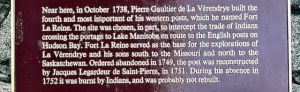
Can you read this? It basically says that the fort wasn’t built on this site, but it was “near here” (so… they don’t really know where it was, exactly) La Verendrye built it in 1738 (as a touchstone for my own self: this was 136 years before Mennonites arrived to what is now known as Manitoba but then was absolutely not yet known as Manitoba). There’s mention of “Indians” on this cairn and I’m thinking the people the cairn is endeavouring to reference were not from India at all, but perhaps people from what is now known as Dakota Tipi First Nation (I’m guessing because the First Nation is located basically right there). So here at this key spot along the Assiniboine River, the French wanted to intercept trade between Indigenous people and the English. This may not have gone super well, as the fort was “ordered abandoned” in 1749. Today it is a National Historic Site of Canada (though that’s interesting as they’re not 100% on where the site actually was).
Prior to this I was familiar with the name La Verendrye largely because it had been the name of a nearby golf course and in the late 90s I thrifted a golf shirt with that name on it and wore it often… not having a clue who La Verendrye actually was.

In examining Google Maps I see that this water treatment plant backs onto the property of the Days Inn that’s situated along the Trans-Canada Highway near Portage, and there’s even a spillway provincial park next to both of them, so I wonder if you could wander over from the Days Inn to this site via the park and possibly at the same time wander over the site of the original Fort la Reine.
It’d be a neat thing to check out this summer!