


WEST RESERVE
When Andrew and I were hanging out in Morden this past spring, I visited the Manitoba Historical Society website to find suggestions for which historic sites we should visit. One site that eluded me was Fort Pinancewaywining. This confused me because I’ve walked around Lake Minnewasta before (with my friend J) and at the time I had absolutely no idea there was a historical site there. But the website seemed pretty resolute, this existed. Plus, Fort Pinancewaywining is mentioned on the Boundary Commission cairn:


Also, Andrew and I just happened to run into this monument on Thornhill Street, at the edge of Morden Park, which is all about Fort Pinancewaywining:


But I felt like I was missing out on noticing the actual historic site as documented on the MHS website. I cannot tell you how many times we drove around looking for this thing. You see, when you walk around Lake Minnewasta, you get to the east side and it looks like you shouldn’t keep going. AllTrails or whatever app J was using when we walked here previously, guided us away from the lake at this point and up into Morden along the southeast edge of the golf course. This gave me the impression we were not permitted to continue down that gravel road. So when Andrew and I went looking for the Fort Pinancewaywining historic site, WHERE WAS IT???
Finally out of desperation I said we should go down that gravel road just so we could say we tried everything. And what did we see? THE HISTORIC SITE WE SOUGHT!
I’m sure this is obvious to everyone except me. Well, at least we finally found it, and I was VERY excited.
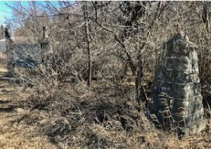
Check out that fieldstone pillar or whatever it is on the right in the picture below. I remember when J and I walked by along the official trail approaching the golf course, I spied an identical pillar in the woods. It fascinated me because it looked SO OLD and I wondered what purpose it served. Now, here’s another. Right next to the sign about Fort Pinancewaywining. And I wonder… have these markers been here since the Fort was established? Do these stones mark the site of the Fort?
Here’s the sign! I really like it because it’s so unusual.

The sign above says:
“PINANCEWAYWINING POST. At or near this site a Northwest Co. trading post was built September 1802 for trading with Cree & Assiniboines. Built by Augustine Cadotte & Antoine Payette under orders from Alexander Henry who was in charge of the main post at Fort Pembina. Here came the first Red River Cart into Manitoba from Fort Pembina.”
Then below that, there are words that are significantly faded, but still legible:
“This site has been sponsored by the Pembina Hills Historical Society.”
I’m guessing that was permitted to fade because perhaps that historical society is no more. I wonder if that means no one is caring for the site? I mean… it doesn’t look like there’s much to it… but then again, what do I know? (Pretty much nothing, honestly.)
So, because I know nothing, I had to look it up a little bit and found metismuseum.ca which states that it’s actually Pinance-way-wining and it means “on the way down to the ford”. Now, I’m also noticing that the way these historic markers mention which Indigenous people they interacted with at the fort, is inconsistent and… I just wonder about. I’d probably lean toward taking the Metis Museum’s word as the last word on this. They say that this fort traded with local Cree, Saulteaux, and Nakoda people.
I appreciate learning more about the history of this region because I do have family history in this region, as my great-great-great-grandparents Jakob and Maria (Fast) Braun are buried in a field just three miles southwest of this spot. However, by 1821 the North West Company merged with Hudson’s Bay Company so really the NWC had morphed quite a bit by the time my ancestors arrived in the 1870s. Yet even still, the activity generated on this site would have affected their lives… probably. I don’t really know anything about the commerce or business of that time so this just exposes more stuff I should be learning.
Thanks for joining me for the journey!

Related:
Checking Out the Boundary Commission Cairn
Learning About History from Murals in Morden
Jakob’s Final Resting Place (After Being Booted Out of Osterwick)