


Up until my interest in local history was ignited, whenever I might’ve heard someone mention Blumengard, I generally assumed they were a little confused, probably meant Blumenort, and I’d check out of that conversation.
But of course I was wrong to make this assumption. Blumengard was its own village, located just several miles west of Blumenort, off what is today the 311.
The Historical Atlas of the East Reserve (yes, here I go mentioning it again, sorrynotsorry) includes this hand-drawn map, which was created by Moray School students in 1965 for their teacher Bert Suss, assigned to interview local seniors about the original village. Thank goodness for such assignments. This is fascinating!

Now. I’ve admitted in previous posts that although I collect and glimpse many historical books, I have not read a single one all the way through. And on the day I convinced a tired Andrew to join me after work for a “quick drive to see just one village site, I promise! just one” I actually knew absolutely nothing about Blumengard — other than how to find it, because I was using the Atlas.

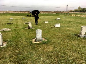
It was a cold fall day, and by the time we arrived at the site, it was raining pretty hard too. I think the length of our visit spanned about three minutes. But, having said that… rainy miserable weather is really the best kind of visiting cemeteries.


So that’s the story of our rainy cranky visit to Blumengard. But what the actual village like?
Well, the first settlers arrived here in 1874, and the village was next to the Steinbach-Winnipeg road (the 311?). It seemed to be a happening village, certainly one of the bigger ones, with its own church (the cemetery is located at what would have been the back of the church lot, according to the map at the top of this post). Although Blumengard folks often did attend church in Chortitz (Randolph) which is only about four miles away. (Chortitz was the ultimate back then.)
The village officially broke up in 1910, although a strong Blumengard/t community remained for many decades. For example, the Moray School District was established here in 1919.

Before this, there had been a private school here… but it seems like the Blumengard folks weren’t that upset about learning English. I mean, the Schools – Our Heritage book says they were initially alarmed… but then dutifully went about building the required school, hiring teachers, etc. I find it interesting that in 1933 there was a note that they asked Peter Falk (presumably not the actor who played Columbo) to build a fire hook — “feuerhacken”. This school district was closed down in 1968, and the children were then sent to either Landmark, Blumenort, or New Bothwell.
The HSHS book Historical Sketches of the East Reserve has an interesting chapter on Blumengart as well, written by Irene Enns Kroeker. Here is a paragraph that she wrote, which I find particularly interesting: “The settlers also made some money by selling butter, eggs, and milk. It was pointed out by a number of women that the lists kept by the settlers showing how much money was made in this was was a representation of only a portion of the income via these means. Women would keep butter, eggs, and milk ‘without the involvement of their husbands’ and use them for trading with the Jewish pedlars arriving at their doorsteps at regular intervals throughout the year or for trading at the stores in larger centres. ‘Men did not always have to know everything.'”
If you have any family history at all in the Blumengard/t area, I highly recommend that you purchase the above-mentioned book, as the sketch written by Irene Enns Kroeker is extremely well-researched, chock-full of detailed photographs and character sketches and stories.
And you’ll also want to visit the Blumengard cemetery, which is a public site, extremely well-kept and easily-accessed by turning north off the 311, onto road 29E.